


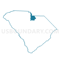
Riverside Voting District, Lancaster County, South Carolina
About
Outline

Summary
| Unique Area Identifier | 666195 |
| Name | Riverside Voting District |
| County | Lancaster County |
| State | South Carolina |
| Area (square miles) | 31.09 |
| Land Area (square miles) | 30.45 |
| Water Area (square miles) | 0.65 |
| % of Land Area | 97.92 |
| % of Water Area | 2.08 |
| Latitude of the Internal Point | 34.77589600 |
| Longtitude of the Internal Point | -80.83712140 |
Maps


Graphs
Select a template below for downloading or customizing gragh for Riverside Voting District, Lancaster County, South Carolina


Neighbors
Neighoring Voting District (by Name) Neighboring Voting District on the Map
- Voting District 022, Union County, NC
- Erwin Farm Voting District, Lancaster County, SC
- Fort Lawn Voting District, Chester County, SC
- Jacksonham Voting District, Lancaster County, SC
- Lansford Voting District, Chester County, SC
- Van Wyck Voting District, Lancaster County, SC
- Wylie Park Voting District, Lancaster County, SC
Top 10 Neighboring County Subdivision (by Population) Neighboring County Subdivision on the Map
- Lancaster CCD, Lancaster County, SC (39,148)
- Van Wyck CCD, Lancaster County, SC (19,729)
- Jackson township, Union County, NC (11,012)
- Fort Lawn CCD, Chester County, SC (5,261)
Top 10 Neighboring Place (by Population) Neighboring Place on the Map
Top 10 Neighboring Unified School District (by Population) Neighboring Unified School District on the Map
- Union County Public Schools, NC (201,292)
- Lancaster County School District, SC (76,652)
- Chester County School District, SC (33,140)
Top 10 Neighboring State Legislative District Lower Chamber (by Population) Neighboring State Legislative District Lower Chamber on the Map
- State House District 68, NC (140,076)
- State House District 45, SC (50,117)
- State House District 43, SC (37,678)
Top 10 Neighboring State Legislative District Upper Chamber (by Population) Neighboring State Legislative District Upper Chamber on the Map
- State Senate District 35, NC (249,030)
- State Senate District 16, SC (121,820)
- State Senate District 17, SC (88,026)
Top 10 Neighboring 111th Congressional District (by Population) Neighboring 111th Congressional District on the Map
Top 10 Neighboring Census Tract (by Population) Neighboring Census Tract on the Map
- Census Tract 112.02, Lancaster County, SC (10,266)
- Census Tract 105, Lancaster County, SC (5,476)
- Census Tract 111, Lancaster County, SC (5,287)
- Census Tract 208, Chester County, SC (5,261)
- Census Tract 210.15, Union County, NC (4,558)
- Census Tract 109, Lancaster County, SC (3,763)